This is the complete guide of Route 40, that runs parallel to the Andes mountain range, through some of the most important tourist destinations in Argentina. It is the highest route in America and the world after the Himalayas.
National Route No. 40, officially called “Libertador General Don José de San Martín” is the longest route in the Argentine Republic, its route crosses from south to north different regions of the country, linking some of the most important tourist destinations. In total it runs through 11 provinces from Cape Virgins, Santa Cruz to the border with Bolivia in the extreme north, in the city of La Quiaca, province of Jujuy. In total the route has a length of 5194 km, crosses 21 national parks, 27 mountain passes, 18 important rivers, reaching at km 4601, almost 5000 meters above sea level in Salta.
Although our subject of interest is the part that crosses Patagonia, we will say by way of general description that through it you can access El Calafate, near the Perito Moreno Glacier, Esquel, El Hoyo, Lago Puelo, El Bolsón, San Carlos de Bariloche, Villa La Angostura, San Martín de los Andes, Junín de los Andes, Malargüe, the Wine Route in the provinces of Mendoza and San Juan, dinosaur fossil sites in the Province of San Juan, hot springs in Catamarca, the Quilmes Ruins, the Calchaquí Valleys, the highest vineyards in the world in Cafayate along the Salta Wine Route, the La Polvorilla viaduct crossed by the famous Train to the Clouds and the Puna.
Route 40 and tourism
The Secretariat of Tourism of the Argentine Nation promoted the development of this route to encourage national and international tourism in western Argentina. As a result of this decision, the Dirección Nacional de Vialidad changed the nomenclature and kilometer markers to unify those previously known as Ruta 40 Norte and Ruta 40 Sur in the city of Mendoza. The official site of Route 40 publishes tourist information about the regions along this route. The Secretariat of Tourism presented an interactive CD entitled National Route 40: Argentina invites you, 5000 km to discover and in 2008 a seminar on National Route 40 was held in the city of San Rafael, Mendoza, where various presentations were made on the works to be carried out on the road and the tourist attractions along the route.
Traffic on this road
Traffic on this road is very low, with an average of less than 1000 vehicles per day, except in two sections: the tourist road between El Bolsón and San Carlos de Bariloche, in the Province of Río Negro, and between Pareditas, in the Province of Mendoza and the City of San Juan. The locality of Pareditas is an obligatory passage for the transfer of vehicles between the cities of Mendoza and San Rafael.
Except for the mentioned sections, the circulation is seasonal, since in vast areas of Patagonia the road is interrupted by snow during the winter season, in the months of July to September. The rivers that cross the route in the north of the country suffer great floods in the summer months, interrupting the road in areas where there are no bridges built.
Patagonian Route
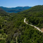
Since its construction began in 1935, the route has changed its route several times, with few paving works, until it received a boost in the 2000s, becoming a national tourist product, following the example of Route 66 in the United States. In 2006, 48% of the route was paved, especially thanks to the works carried out in the province of Santa Cruz and to changes made in the route, taking advantage of sectors of already paved routes close to the Andes Mountain Range.
The following is a description of the most important tourist areas of this route from south to north, the description of each province, and the localities according to the departments where they are located.
Province of Santa Cruz
The road begins at the lighthouse located at Cape Virgins on the coast of Santa Cruz from where the Strait of Magellan can be observed, this is the most southeastern point of the Atlantic coast of the continental area of America, although the southernmost point is located a few kilometers further south: Punta Dungeness. After crossing the provincial capital, Río Gallegos, overlapping with National Route 3 for a stretch of 35 km, it heads west along the Gallegos River valley to the mining town of Río Turbio, and from there to the north. Upon reaching Lake Argentino, it passes 32 km from the tourist town of El Calafate, gateway to Los Glaciares National Park, which includes the Perito Moreno Glacier. Further north it borders other lakes, such as Lake Viedma and Lake Cardiel, then reaches the Bajo Caracoles spot where there is a 42 km dirt road called Provincial Route 97, which leads to the Cueva de las Manos, which has cave paintings with an antiquity close to 10,000 years old. Finally it crosses the town of Perito Moreno, to reach the interprovincial limit with Chubut.

The following localities are located along the aforementioned route:
Güer Aike Department: Punta Loyola (km 100), Río Gallegos (km 134-135), Rospentek Aike (km 376), Veintiocho de Noviembre (km 390) and Esperanza.
Lago Argentino Department: access to El Calafate (km 594).
Río Chico Department: access to Gobernador Gregores (km 891).
Department of Lago Buenos Aires: Perito Moreno (km 1251).
Province of Chubut
In the province of Chubut, the route is located in the west of the province, crossing several towns such as Río Mayo, Gobernador Costa, Tecka, near the tourist city of Esquel, the terminal station of the La Trochita Viejo Expreso Patagónico railroad and the entrance point to Los Alerces National Park. Further north, almost on the border with the province of Río Negro, the route passes 5 km from Lago Puelo, next to Lago Puelo National Park.

The following localities are located along the above mentioned part of the route:
Department of Río Senguer: Río Mayo (km 1362).
Tehuelches Department: access to José de San Martín (km 1590) and Gobernador Costa (km 1594).
Languiñeo Department: Tecka (km 1676).
Futaleufú Department: access to Esquel (km 1763).
Cushamen Department: access to Epuyén (km 1866), El Hoyo (km 1901), and access to Lago Puelo (km 1907).
Province of Río Negro
With the Andes Mountain Range always in sight, Route 40 continues its route northward passing through the cities of El Bolsón and San Carlos de Bariloche, the most visited city in Patagonia. In the town of Río Villegas is the entrance to Nahuel Huapi National Park. In Villa Mascardi is the access to Cerro Tronador. Although to be precise, the route does not enter the city of San Carlos de Bariloche, but runs through a variant that was built in the 2000s. The last town it crosses in the province is Dina Huapi, on the eastern shore of Lake Nahuel Huapi.

The following localities are located on the above-mentioned route:
Bariloche Department: El Bolsón (km 1914-1916) and San Carlos de Bariloche (km 2031-2046).
Pilcaniyeu Department: Dina Huapi (km 2054).
Province of Neuquén
In the province of Neuquén, after crossing the Limay River, the route continues to the left towards Villa La Angostura, to reach the famous Seven Lakes Road, inside the Lanín National Park. The route continues to the north passing by the beautiful city of San Martín de los Andes and then Junín de los Andes. Continuing north, you will find Zapala, the railhead of the General Roca Railroad, Las Lajas and Chos Malal. In the town of Barrancas is the Colorado River, natural boundary with the province of Mendoza, the point where our note ends to reach the limits of the Patagonian region.
Sporting milestone in Running
From August 17, 2015 to December 2, 2015, ultramarathon runner Rodolfo Rossi, 40 years old, ran on foot the Ruta 40, from La Quiaca to Cabo Virgenes, in 107 days, averaging 50 km per day. He continued his march along Route 3, already in Tierra del Fuego, from December 3 to reach Ushuaia on December 8, managing to unite Argentina from North to South, in its entirety, running. He was the first man in history to do so. He was accompanied by a support team of seven people, and thousands of people joined him running some stretches along the route.
Since 2010, the Desafío Ruta 40 rally competition has been held annually along the route, representing the most important date of the Argentine Cross Country Rally Championship.
Culture and Route 40
In 1998 the Catalan writer and traveler Enric Soler i Raspall published Per la ruta 40: a través de la Patagònia de Bruce Chatwin (Along Route 40: through Bruce Chatwin’s Patagonia) recounting his journey following, 22 years later, the steps of the writer Bruce Chatwin as told in his book En la Patagonia (In Patagonia).
In the 2004 film Diarios de motocicleta (Motorcycle Diaries), based on the travel diaries of Che Guevara and Alberto Granado, several sections of this route are shown. In 2006 the Argentine hard rock band La Renga composed a song called “Ruta 40”, which is included in the album Truenotierra, released on December 13, 2006.
In 2011 a documentary series from Córdoba called “La 40” was released, directed by Pepe Tobal, which travels the entire route from La Quiaca to Cabo Vírgenes, in a Mercedes Benz 1114 bus, model 1961, with a group of itinerant musicians.
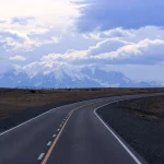
*Main photo: The Cordillera Paine, Chile, as seen from route 40 in Santa Cruz, Argentina. Author: Martin St-Amant (S23678), CC BY-SA 3.0 via Wikimedia Commons
In conclusion
Traveling the Ruta 40 is much more than a trip: it is a journey through the soul of Argentina, crossing unforgettable landscapes, towns with history and unique corners waiting to be discovered. Whether you plan to do the whole journey or just a section of it, this route guarantees an authentic and transformative experience.
If you are thinking of traveling through Argentina and are looking for adventures that combine nature, culture and freedom, Route 40 is your next must-see destination. Have you already traveled it? Share your experience in the comments and continue exploring our articles about tourism in Patagonia to plan your next getaway.


 13")