The Search for an Elusive Passage and the Disappearance of an Imaginary River
There is various evidence and theories, some of them unproven, regarding the arrival of European and Asian navigators to the American coasts before the year 1492. While much of the evidence is controversial and debatable, except for the case of the Viking settlement in Canada where there is a…
Machine translation.
The history of the arrival of the first European navigators to the coasts of Patagonia is full of uncertainties, as the testimonies that reach us from those times do not abound in details and contain inaccuracies and contradictions that fuel various theories.
There is different evidence and theories, some of them unproven, about the arrival of European and Asian navigators to the American coasts before the year 1492. While much of the evidence is controversial and debatable, except for the case of the Viking settlement in Canada where there is a widespread consensus, it is no less true that the official history leaves enough gaps that have not been properly filled.
In this particular entry, I want to focus on a couple of issues that I discovered thanks to a contribution from my friend Héctor García (who is always throwing ideas my way for research) and through reading the biography of Magellan written by Stefan Zweig in 1938. The first question, in a nutshell, is: Did Magellan have prior information about the existence and location of the passage that connects the Atlantic and Pacific Oceans? And if he had that information, where did he obtain it? Was it reliable? Did Magellan know what he was going to find, or was it a stroke of luck? The second question, somewhat related to the first, is about a Patagonian river that appears represented in the oldest maps and that disappeared from them over the years. Let us then delve into these questions.
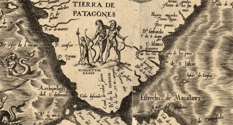
The map that illustrates this article is a portion of the map of America made by Diego Gutiérrez (1562), at the request of the Spanish crown, where we can see the "Gigantum Regio," the "Land of the Patagonians" that would fuel many stories for centuries. Here we find several historical questions, two of which I will address in this entry. One of them is the Strait of Magellan, and the other is the Cananor River. We can also find the Bay Sin Fondo marked, which gives its name to my blog. Source: Wikimedia.
A strait too hidden
To set the scene for this matter, I will let Zweig throw the first stone:
"Everywhere, North, South, in the ice zones and in the tropical latitudes, always the same unbreakable barrier of land and stone. Hope is already beginning to fade. Some cartographers are already recording South America as united to the Antarctic Pole. No one believes anymore in the possibility of reaching from the Atlantic Ocean to that other one that Núñez de Balboa saw from the heights of the mountain range and that undoubtedly was confused with the 'mare indicum.' Too many ships have already shipwrecked in that futile search; once again, the dream of that desired cape fades away."
"Then suddenly this unknown, Fernando de Magellan, emerges from the anonymity of his insignificant existence and declares: 'There is a passage. I know it. Ruy de Faleiro and I are the only ones on earth who know its position. Give me a fleet, and I will show you this passage, and sailing from East to West, I will circumnavigate the entire world.'"
Perhaps Zweig's words were not the same as those used by Magellan when he presented his project to the King of Spain, but it is clear that Magellan made a very strong bet by setting sail west and south, which in my view can only be explained in two ways: either he was like that player who bets everything he has despite having mediocre cards in hand, hoping that the opponent will fold, or, on the contrary, he is the one who bets knowing that his opponent has nothing. The mystery is unveiled by the testimony of Antonio Pigafetta, the chronicler of Magellan's voyage, who claims that the Portuguese navigator's conviction about the existence of a strait that would allow access to the spice islands was based on cartographic data restricted to which he had access (something like confidential material). In Pigafetta's own words:
"This man [Magellan], as skilled as he was brave, knew that it was necessary to pass through a very hidden strait, but that he had seen depicted on a map that the King of Portugal kept in his treasury, made by Martin of Bohemia, a very excellent cosmographer."
The presumed author of the map, Martin of Bohemia, is none other than Martin Behaim, the creator of the oldest globe that is preserved. Could Martin Behaim have been the holder of the secret of the strait? Everything seems to indicate that it is not possible. Martin Behaim was a cartographer at the court of the King of Portugal until 1507, the year he passed away. Undoubtedly, Magellan and Faleiro saw his maps, but at the time of Behaim's death, not many expeditions to America had been made, except for the voyages of Christopher Columbus and Pedro Alvares Cabral (discoverer of Brazil). Who else could have navigated so far south as to discover, or intuit, the location of the strait? There are a few candidates, but none of them ventured that far south: Cristobao Jacques, Gonzalo Coelho, Joao de Lisboa, Dom Nuño Manuel, and Vasco Gallego. They all share a common factor; they are employees of the Belgian shipowner Christopher (Cristóbal) de Haro, who wants to find a passage to reach India, but in the meantime, he also trades in timber extracted from Brazil.
A possible explanation for the map mentioned by Pigafetta can be found in a globe made by the German mathematician, cartographer, and globe maker Johannes Schöner in 1515. There is a passage drawn that connects the two oceans, years before there was concrete information about what is now called the Strait of Magellan. In this globe, the passage is located between the southern tip of America and a southern land, surprisingly similar to Antarctica, referred to as "Brazilie Regio." The same German cartographer explains, in a treatise he published in 1515 titled "Luculentissima quædam terræ totius descriptio" (a very lucid description of all lands), where he obtained the information about the strait:
"The Portuguese navigated in this region, Brazil, and discovered a passage very similar to that of our Europe, which runs East-West. From one side, the other shore can be seen, and the cape [the end of the strait] of this region is about 60 miles away, as if one were sailing through the Strait of Gibraltar between Seville and Barbary (…). Beyond that, the distance is not very great from this region of Brazil to Malacca, where the apostle Saint Thomas was martyred."
Comparison, in a square representation, of the maps of Waldseemüller and Schöner. In Waldseemüller's map (1507), it can be seen that the American continent ends just beyond the 40º south parallel. However, this termination of the continent only indicated how far it was known, or suspected, that land existed. Schöner's map (1515), on the other hand, is much more complete, as it clearly marks the existence of a strait between what is the American continent and a continent identified as "Brazilie Regio," which could be associated with Antarctica. This error in Schöner's map may have misled Magellan in his quest. Source of both maps: Wikiwand.
In a German gazette or pamphlet of just five pages, published in 1514 with the title Copia der Newen Zeytung aus Presillg Landt (copy of the most recent news from the land of Brazil), seems to be the source from which Schöner extracted the information about the Portuguese voyages. It recounts a Portuguese journey that reached the mentioned strait at 40º south latitude and even managed to cross it, but storms forced them to return without being able to progress northward.
"Know that on the 12th day of the month of October, a ship from the Brazilian country has arrived here that was armed and chartered by Nono and Cristóbal de Haro. They are two ships that, with the permission of the King of Portugal, have set out to explore and discover the land of Brazil... and when they arrived at a climate or region at forty degrees of latitude, they discovered Brazil with a Cape that is a place that enters the sea. And they turned around the Cape and found that it is situated, like Europe, with the west in front, meaning that it is placed between the East and the West. On the other side, they also found land... and when they turned around the Cape, as has just been communicated, and took a northwest course, such a storm broke out that they could not continue sailing. Then they had to return by Tramontana, that is, to the land of Brazil. The pilot, that is, the captain of that ship, is a good friend of mine..., he tells me and believes that from that Cape of Brazil there should not be more than six hundred miles to Malacca. He also proposes to make such a journey from Lisbon to Malacca and back soon, and believes that he will render great service to the King of Portugal by bringing spices..."
Cover and excerpt from the Copia der Newen Zeytung aus Presillg Landt where the expedition of Cristóbal de Haro is mentioned, which would have sighted a passage at 40º south, which at most could have been the Gulf of San Matías. Source: Archive.org
If the German cartographer took, and misinterpreted, this information regarding the passage, it explains why he drew it on his globe, including the error in latitude (about 40º instead of the actual 52º of Cape Vírgenes, where the Strait of Magellan begins). Everything points to the fact that, in reality, the passage referred to by both Copia der Newen Zeytung aus Presillg Landt and Schöner himself would correspond to the estuary of the Río de la Plata or the Gulf of San Matías, located approximately at 40º south latitude.
Comparison between Schöner's view in 1515 (left) and reality (right). Apparently, the Portuguese navigators had reached the Gulf of San Matías and believed they had found the passage to the spice islands. If they had not been caught by storms, as reported in the Copia der Newen Zeytung aus Presillg Landt, perhaps those navigators would have discovered that there was no strait at 40º south, and who knows if Magellan would have embarked on his journey (of course, it would be an alternative history that we will never know). Source: Universitas Miguel Hernández
Therefore, the question of whether Magellan knew of the existence of the strait can be answered with both a "yes" and a "no." Rather, he believed he knew that a strait existed and where it was, but the information he possessed was erroneous, albeit only regarding latitude, because the strait did exist, a dozen degrees south of where he assumed.
An nonexistent river in the current Chubut territory.
The maps of the new lands discovered by European navigators evolved over the years, increasingly shaping the coastline and geographical features more consistently. In this geographical metamorphosis, islands, rivers, gulfs, and capes appeared and disappeared as more sailors traversed the same waters and corrected the errors of previous nautical charts. Patagonia is no exception to this process; if we look at some of the ancient maps (see previous notes here and here), we will notice many changes between the primitive maps of the 16th century and the much more realistic ones of the 19th century. The purpose of this entry is not to conduct an exhaustive analysis of this topic, which could take a long time and perhaps I will address it in a future article (I am particularly interested in the issue of the Pepys Islands, or San Pedro, or Sansón, which may possibly be the Falkland Islands), but I will pause for a few lines to search for a Patagonian river that never existed: the Cananor River.
Map by the Genoese cartographer Nicolás Caverio (1502), where the "Río de Cananor" is marked as the last geographical feature of the American continent. To better understand the map, it is represented with the south at the top, so the text can be read correctly. Source: World Digital Library
Map Kunstmann II (1502), where we also find the "Río de Cananor" as the last geographical feature of the American continent (almost illegible). Source: World Digital Library
The Cananor River appears in several maps from the early 16th century: Kunstmann II (1502), Caverio (1502), Maiollo (1504), and Waldseemüller (1507). Even in Schöner's map, this river is clearly marked (see figure with the square representation of this map). The name is striking, as it does not correspond to any date in the Catholic calendar at a time when it was common to use the names of saints to name geographical features. The writer Germán Arciniegas presents a curious hypothesis about the origin of this name:
“Cananor was a memory of the East that impressed both the Portuguese and the Florentines. Cananor and Cochin were the two most important export ports for pepper and cinnamon on the Malabar coast. Pepper originated in Malabar, and in Florence, pepper was consumed more than any other spice. It was used in cooking and in pharmacy and was valued as currency.”
From there, according to Arciniegas's hypothesis, it follows that Amerigo Vespucci was the discoverer of this enigmatic river in southern Patagonia. I do not want to dwell on a topic that exceeds this note, but it is worth remembering that everything related to Amerigo Vespucci's travels is very controversial, and today most of his journeys to the New World have been questioned.
Another history scholar, Enrique de Gandía, claims that the name of the river is related to the imaginary name of a king from a chivalric novel from the late 15th century: "La hystoria del rey Canamor y del infante Turián su hijo y de las grandes aventuras que huvieron". However, this chivalric story seems to have been published in Spain in 1562, which would not explain the presence of the name Cananor in maps from 1502 to 1515.
The southern coast of the American continent that appears in the map of Maiollo (1504) bears a certain resemblance to that represented in Kunstmann's (1502). Here we also find the "Río de Cananor" as the last geographical feature of the American continent.
From the ill-fated expedition of the adelantado Simón de Alcazaba y Sotomayor, it is known that “On the 3rd of the said month, I took the sun at forty-six and a half degrees; on this day we saw land, at the entrance of the Cananor River, which is a large bay and enters to the west-northwest and along the northern shore; which is high land; and to the southwest and south-southwest to the south, which is low land like an island and comes to the sea eight leagues.” Nothing more about this river was left by Alcazaba's expedition, which founded a fleeting Patagonian settlement before the city of Buenos Aires was founded for the first time.
With differences in its spelling (Cananor, Cananea, and others, which possibly derived into Camarones), the ghostly river appeared and disappeared from maps and texts for centuries. We can find it in the cited maps from the early 16th century to others from the second half of the same century (Gutierrez, 1562) or even in some maps from the 19th century (Cary, 1807). The 1883 expedition of Lino Oris de Roa puts an end to this mystery, reporting its non-existence. From then on, historians and geographers began to wonder about the source from which this nonexistent river emerged, which in turn could be the origin of the name Camarones.
In Waldseemüller's map (1507), the "Río de Cananorȗ" (sic) appears at the end of the continent, so far at the end that it almost escapes the limits of it. Source: World Digital Library.
The writer Héctor Raúl Ossés deduces in his book “Patagonia, ficción y realidad” that "it is likely that the mouth is only the final part of the Salado, a very important temporary ditch, which has large canyon tributaries located to the west of Camarones, on the Pampa de La Lochiel, Montemayor plateau. When summer arrives, the snow and ice from those pampas, plateaus, and canyons flow into the sea through the ditch.” There are people in the area who claim that, around 1899, the Salado flowed permanently for 25 kilometers. Perhaps that is the explanation for a river that appeared to flow abundantly on maps but was likely just the drainage of the plateau, an important ditch.
In John Cary's map (1807), the Cananor River is no longer present, but in its place appears an equally nonexistent river, the "Camarones River." This is one of the last appearances of the Cananor River, or Camarones, on maps. As the 19th century progressed, the river that marked the end of the American continent in the early maps of the 16th century began to fade away. Source: David Rumsey Map Collection.
Final Words
In today's entry, I have tried to condense two stories that share many parallels and relate to ancient maps and the early European navigators who explored the Patagonian coast. The passage of these early navigators along the Patagonian coasts, whether Portuguese or Spanish, is partially obscured by the absence of more exhaustive records of their journeys, and except for Magellan, who has Pigafetta to provide a chronicle, there are not many records left of the other travelers. Since these were not scientific expeditions, but rather commercial-military ones, it is clear that there was no interest in what they found or saw unless it had strategic or commercial importance. The question of whether the existence of the strait was known in advance is hardly answerable now, 500 years later. On the other hand, the history of the Cananor River will also remain vague, beyond the hypotheses we can weave. The Cananor River could well have been the current Chubut River; after all, the early maps were very approximate, and latitude measurements could be erroneous.
Dear blog followers, I leave you here to draw your own conclusions.
By Patricio Donato
Researcher at CONICET (Smart Electric Networks)
Enthusiast of the history of Patagonia
Editor of the blog Bahía Sin Fondo
Share
Rate this story
No ratings yet
0 comments
No comments yet. Be the first!
You may also like
 Getaway to Bariloche: 3-Day Itinerary and My First Time in the Snow at 50
 Fulfilling the Dream of Traveling to Ushuaia
 Journey of the Sailboat Galileo in Patagonia and Argentine Antarctica - 2nd part -
 Journey of the Sailboat Galileo in Patagonia and Antarctica by Commander Navas
 Ushuaia, the City at the End of the World… where everything begins
 An Unsettling Experience in Victoria Island
 Jurassic Park in Southern Patagonia
 156 Years Ago, the Ship Mimosa Set Sail for Patagonia